EuroVelo 15 Rhine Cycle Route — Stage by Stage Guide
The EuroVelo 15 Rhine Cycle Route is 1,233 kilometres of some of the most varied, beautiful, and genuinely rideable long-distance cycling in Europe. I completed the full route over 18 days in May two years ago, starting from the Rhine’s source in the Swiss Alps and finishing at the Hook of Holland on the North Sea coast. What I found was a route that tour operators package into sanitised highlights reels and that the official EuroVelo site describes in broad strokes — but nobody had given me the granular, day-by-day information I actually needed before I left. This guide is the one I wish had existed. Four countries. Four distinct landscapes. One river, followed almost entirely from birth to sea.
Route Overview and Best Time to Ride
The Rhine rises at Tomasee lake near Oberalp Pass in the Swiss canton of Graubünden at roughly 2,344 metres above sea level, and it empties into the North Sea near Rotterdam and Hoek van Holland. The official EV15 route traces it for 1,233 km through Switzerland, France (specifically Alsace), Germany, and the Netherlands. That is not a weekend ride. Most cyclists take between 16 and 22 days, depending on fitness, daily distance appetite, and how many afternoons they lose sitting in riverside beer gardens. Spoiler — you will lose at least three afternoons that way.
The route passes through four distinct cycling cultures. Switzerland is precise and signposted but expensive. Alsace is charming and occasionally confusing. Germany is a cyclist’s paradise with dedicated infrastructure. The Netherlands is flat, fast, and extraordinarily well signed with its numbered junction network.
Elevation Profile — What to Expect
The opening stages through the Swiss Alps involve real climbing. The first 200 kilometres feature cumulative elevation gain that will test loaded tourers. Once you reach Basel, however, the route levels out dramatically. From Basel to Karlsruhe is almost billiard-table flat. There are minor undulations through the German Middle Rhine gorge between Bingen and Koblenz — the terrain there wrinkles just enough to keep it interesting — but nothing genuinely steep after Switzerland. The Netherlands is flat in the way only the Netherlands can be: aggressively, almost defiantly flat.
Best Time to Ride
May through September is the window. I rode in May and it was close to perfect — temperatures between 16°C and 24°C most days, long daylight hours, and accommodation not yet at summer-peak prices. June and July are busier and hotter, particularly through the Rhine Gorge where the valley walls trap warmth. August is peak season everywhere; book accommodation two to three months ahead if you’re riding then. September is arguably the best month for the German and Dutch sections — harvest time in wine country, lower crowds, golden light.
Avoid April. I had a friend attempt it in early April and she hit persistent rain and cold from Chur through to Strasbourg. Not dangerous, just miserable in a way that erodes enthusiasm by day four.
Route Marking and Navigation
In Switzerland the route follows National Route 2 (Rhone Route, confusingly — the Rhine is German for Rhein, and Swiss signage switches between languages). Navigation in Switzerland requires either a good paper map from Kümmerly+Frey or a GPS device loaded with the Komoot route. I used a Garmin Edge 830 with the EV15 route downloaded from the official EuroVelo GPX files, and it worked without issue through all four countries except one baffling detour near Worms where the GPX and the on-the-ground signs disagreed. I followed the signs. That was the right call.
Germany uses a combination of EuroVelo signs and regional cycle route markers. The Netherlands is signed via the knooppunten (junction point) network, which is genuinely the best cycling navigation system in the world.
Stage 1–3 — Switzerland to Alsace
Probably should have opened with this section, honestly, because the Alpine start is what separates the Rhine route from every other flat river ride in Europe. Reaching the source takes effort and that effort pays dividends in scenery, solitude, and the particular satisfaction of knowing exactly where your river begins.
Stage 1 — Oberalp Pass to Chur (approximately 95 km)
The official start point at Tomasee lake sits at 2,344 metres. Getting there requires either a train (the Glacier Express stops at Oberalp Pass) or a brutal climb from Andermatt. I took the train from Zurich to Oberalppass with the bike in the luggage car — cost me 47 CHF including the bike supplement — and started riding from there. Descending from the pass toward Disentis is exhilarating and fast. The road surface is good. The drop to Chur covers around 1,600 metres of descent over 95 kilometres.
Chur is Switzerland’s oldest city and a genuinely appealing stop. Accommodation recommendation — Hotel Duc de Rohan on Masanserstrasse has secure bike storage, which matters. Rates around 110–130 CHF per night for a double. The old town is compact, walkable after a day in the saddle, and has good restaurants in the Poststrasse area.
Stage 2 — Chur to Schaffhausen (approximately 130 km)
This is a big day and a demanding one. The route follows the Rhine through the Rhine Valley (Rheintal) past Bad Ragaz, Sargans, and along the Liechtenstein border — you cycle through the principality briefly near Vaduz, which gives you a fourth country stamp if you carry your passport, though Liechtenstein is not one of the official EV15 countries. The terrain is gentler than Stage 1 but there are several short climbs between Buchs and Stein am Rhein.
Stein am Rhein is worth a lunch stop. The medieval old town’s painted facades are the most photographed streetscape in Switzerland east of Zurich. It is also the point where the Rhine leaves the Bodensee (Lake Constance), which the route skirts along the southern shore. Schaffhausen is the overnight stop and deserves an early arrival because the Rhine Falls (Rheinfall) — the largest waterfall in Europe by volume — is three kilometres outside the city at Neuhausen. Go in the evening when the tour groups have gone home. The falls run at 700 cubic metres per second in May.
Stage 3 — Schaffhausen to Basel (approximately 110 km)
Rolling terrain, vineyard villages, and the approach to Basel through the Hochrhein section. The route passes through Waldshut-Tiengen, briefly crossing into Germany before returning to the Swiss bank. The cycling infrastructure improves noticeably as you approach Basel. Basel itself is the pivot of the entire journey — the point where Alpine Switzerland becomes flat Rhine Valley, and where the river begins its long northwest trajectory toward the sea.
Exhausted by three big days of Alpine and sub-Alpine riding, I spent two nights in Basel. This was the right decision. The city rewards the time. Kunstmuseum Basel has a cycling-relevant collection of zero percent but is one of the best art museums on the continent and the entry fee of 26 CHF is worth it. The Rhine swimming culture in Basel — locals float downstream in the current using waterproof bags called Wickelfisch — is something I’d never seen before. Ride weight and tired legs aside, I jumped in. The water in May is cold. Very cold. About 14°C cold.
Stage 4–6 — Rhine Valley Germany
The German Rhine is what most people picture when they imagine this route. Castles on crags, steep vineyard terraces, the slow parade of long cargo barges pushing upstream, and the particular quality of evening light in the gorge that turns the river the colour of hammered pewter. It is legitimately as good as it looks in photographs.
Stage 4 — Basel to Karlsruhe (approximately 150 km)
Flat. Very flat. The Upper Rhine Plain (Oberrheinebene) stretches north from Basel between the Vosges mountains to the west and the Black Forest to the east, and the river meanders through it with minimal gradient. This is the longest day in terms of distance on my itinerary and I covered it in just under eight hours including stops.
The route alternates between the French (Alsace) and German banks through this section. Strasbourg sits on the French side and is a mandatory detour — cross the Pont de l’Europe and spend the afternoon there. The Grande Île UNESCO district, the cathedral with its single complete tower, the Petite France canal quarter. Strasbourg is a serious city and deserves serious time. I had three hours and it wasn’t enough.
Freiburg im Breisgau on the German side is worth a detour too, though it sits about 30 km east of the Rhine. I skipped it on this ride and regretted that later when a friend told me the Rathausplatz market alone is worth the deviation.
Karlsruhe is a functional overnight stop — nothing more. Hotel Rio on Ettlinger Strasse is clean, cheap (around €65 per night), and has a locked bike room. Book ahead in summer.
Stage 5 — Karlsruhe to Bingen (approximately 155 km)
The scenery upgrades significantly north of Mainz. The first half of this stage, Karlsruhe to Mannheim and Mainz, is industrial Rhine — big river, big barges, chemical plants, and the occasional rewarding old town. Speyer has a Romanesque cathedral that is UNESCO-listed and visible from 10 kilometres away. Worth 45 minutes off the bike. Worms has the Nibelung Bridge and Luther associations and the best Zwiebelkuchen (onion tart) I ate on the entire route, from a bakery on Ludwigstrasse whose name I failed to write down. That was a genuine mistake and I’m still annoyed about it.
Mainz is a city I underestimated. The old town near the Dom is livelier than its reputation suggests and the riverfront promenade is excellent for an evening walk after checking into accommodation. From Mainz, the route heads into the Rhine Gorge proper. The last 30 kilometres before Bingen are a warm-up for what comes next.
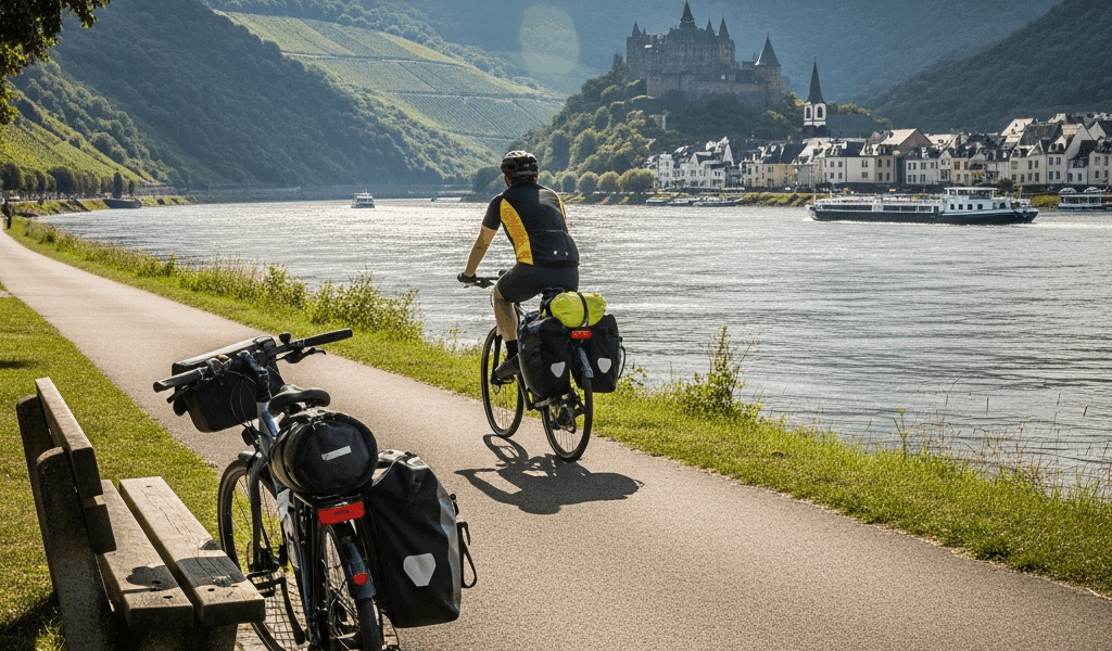
Stage 6 — Bingen to Koblenz (approximately 65 km) — The Gorge
Short stage. Deliberately short. The Middle Rhine Gorge between Bingen and Koblenz is 65 kilometres of concentrated castle-and-vineyard spectacle and it deserves to be ridden slowly. This is the section you have seen in every Germany tourism photograph: the Loreley rock, Burg Gutenfels above Kaub, the twin towers of Liebenstein and Sterrenberg facing each other across a shared spur, Burg Rheinfels above St Goar. Twenty-plus castles in 65 kilometres.
The route runs along both banks and you can mix and match via the small car ferries that cross the river at regular intervals. The ferries run on a simple flat rate — usually around €2.50 for a cyclist — and are a routine part of local commuting. I crossed four times over two days in this section, just because I could.
Bacharach, midway through the gorge, is where I stayed and I cannot recommend it highly enough. Pension Krannenturm occupies part of a genuine medieval town wall tower. The basic double rooms are around €70 per night. You sleep inside a 14th-century fortification. The breakfast is enormous.
Koblenz marks the confluence of the Rhine and Moselle (the Deutsches Eck monument sits at the exact meeting point) and is a logical stage end. The Deutsche Eck is touristy in the best possible way. There is an enormous equestrian statue, good ice cream vendors in summer, and a cable car up to Ehrenbreitstein Fortress across the river that runs for €7.90 return.
Stage 6 Continued — Koblenz to Cologne and Beyond
North of Koblenz the Rhine widens and the scenery shifts from gorge drama to a gentler, broader river landscape. Bonn, Cologne, Düsseldorf. These are cities with weight and character. Cologne’s cathedral — the Kölner Dom — took 632 years to complete and announces itself from 15 kilometres away on a clear day. The cycling infrastructure through the Cologne metropolitan area is genuinely impressive; separated bike paths run continuously through the city centre.
The route from Cologne to the Dutch border passes through Düsseldorf, Duisburg, and the industrial Ruhr confluence, which is less scenic but has its own gritty fascination. The Netherlands begins near Kleve and the transition is immediate and total — suddenly everything is flat, signed, and optimised for bicycles.
Planning Logistics and Gear
The practical questions are where most potential riders get stuck. Distance and scenery are the easy parts. Getting the logistics right — what to ride, what to carry, where to sleep — is what separates a smooth trip from a miserable one.
Choosing the Right Bike
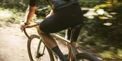
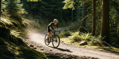
A touring bike or a gravel bike with 35mm–40mm tyres is the correct choice for EV15. The route is almost entirely paved — only a handful of short sections in Switzerland use gravel paths — so you do not need aggressive off-road tyres. I rode a Surly Long Haul Trucker with 38mm Schwalbe Marathon Plus tyres and experienced zero punctures in 1,233 kilometres. That is not a coincidence; the Marathon Plus is extraordinarily puncture-resistant at the cost of some rolling weight.
E-bikes are increasingly common on this route, particularly among older riders doing the gorge section. They make complete sense for the Swiss stages. The charging infrastructure at hotels throughout Germany and the Netherlands is now reliable enough that range anxiety is not a real concern.
Do not attempt this on a road bike with 25mm tyres and no rack. Someone in Bacharach was doing exactly this with a framebag setup and a credit card. She looked comfortable but I don’t know how she was managing the physical weight of carrying nothing.
What to Pack — Panniers vs Framebags
Four panniers is the traditional touring setup and it remains the most practical for a multi-week trip. I used Ortlieb Back-Roller Classic panniers (40 litres total) plus a small Ortlieb handlebar bag for items I needed access to without stopping — phone, snacks, rain jacket. Total loaded weight was approximately 18 kg including the bike.
The key items beyond standard touring kit that I found specifically useful on this route: a compact packable down jacket (I used the Patagonia Down Sweater) for cool Alpine mornings that warm to 22°C by noon; a lightweight lock for leaving the bike outside restaurants (Abus Bordo 6000/90 folds flat into a pannier); and a physical backup map because GPX files and phone batteries do not always cooperate simultaneously.
Accommodation Strategy
Three options work well on EV15: hotels and pensions (most common), campsites (plentiful along the river), and cyclist-specific accommodation through the Bett+Bike network in Germany.
Bett+Bike is the most useful thing I discovered on this trip. It is a certification programme run by the ADFC (German cycling federation) that identifies accommodation offering secure bike storage, a drying room, and an early breakfast option for riders. The searchable database at adfc.de/bett-und-bike lists thousands of properties throughout Germany. Almost every overnight stop I made in Germany was Bett+Bike certified. Prices ranged from €55 to €95 per night for a single room with breakfast.
In Switzerland, book everything ahead — accommodation fills fast and prices spike if you’re searching same-day. In the Netherlands, the campsite network is so dense that spontaneous camping works fine in summer. The Dutch ANWB has a campsite finder that is more useful than Google Maps for this purpose.
Daily Distance — Realistic Expectations
Most cyclists comfortable with touring manage 70–100 km per day loaded. The EV15 averages out to about 68 km per day over 18 days, but the distribution is not even.
Stay in the loop
Get the latest cycle routes world updates delivered to your inbox.