What Is the Great Divide Mountain Bike Route
The Great Divide Mountain Bike Route has gotten complicated with all the misinformation flying around. As someone who spent weeks researching this route before my first attempt — then actually rode it — I learned everything there is to know about what this trail really is. Today, I will share it all with you.
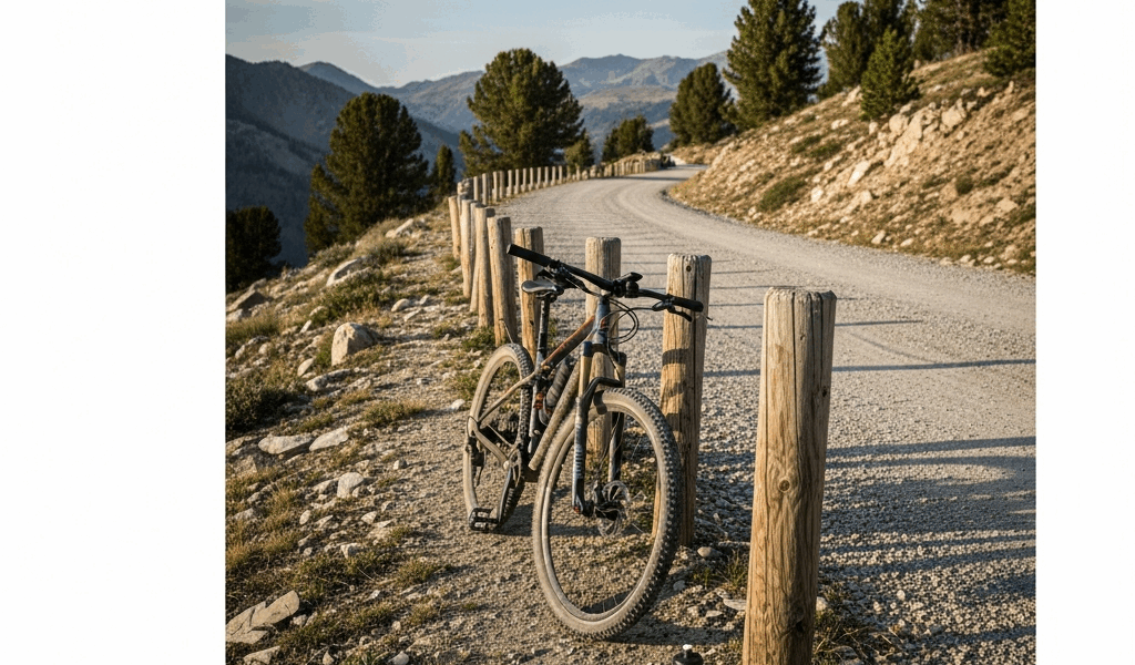
I kept expecting singletrack. Fast, technical descents through pine forests, the kind of stuff that fills bike YouTube. What I actually found was something else entirely: a 4,400-kilometer (2,700-mile) gravel and dirt road odyssey stretching from Banff, Alberta all the way down to Antelope Wells, New Mexico. Following the Continental Divide the whole way.
But what is the GDMBR, really? In essence, it’s a self-supported bikepacking route designed by the Adventure Cycling Association in the 1990s. But it’s much more than that. Here’s what nobody mentions in the polished blog posts — this is not a mountain bike route in the modern sense. You won’t need a full-suspension enduro rig worth $6,000. A rigid steel gravel bike or a hardtail with 40mm clearance works fine. Forest service roads, jeep tracks, occasional pavement. No gnarly singletrack anywhere.
The route crosses the Continental Divide more than 30 times. Sounds impressive until you realize that also means 30+ significant climbs. Many push 2,000 meters of elevation gain in a single day. The surface shifts constantly — hard-packed dirt gives way to washboard corrugated roads, then suddenly you’re grinding through ankle-deep sand somewhere in the high desert. Some sections are smooth enough for a road bike. Others demand every millimeter of your tire volume.
Best Time of Year to Ride the Great Divide
Probably should have opened with this section, honestly. Timing determines everything on the GDMBR, and the conventional wisdom — “ride it anytime in summer” — will get you pushing a loaded bike through snow, hail, or mud that swallows your wheels entirely.
North-to-south is the dominant direction, and there’s a real reason for that. Starting from Banff in mid-June lets you chase the season south. You miss the spring snowmelt chaos in Canada and Montana, sidestep the worst July heat in New Mexico, and finish before October storms move through the high country. Don’t make my mistake. I started a Colorado section in early May — mud made certain roads genuinely unrideable. We lost two full days to a 15-kilometer stretch that should have taken two hours. Two hours.
Here’s the seasonal reality broken down by month:
- May: Mud season across Montana, Wyoming, and Colorado. High mountain passes still holding snow. Risk is high; reward is low.
- June: Optimal for the northern sections — Canada, Montana. Snow melting fast. Roads dry out significantly by late June.
- July: Perfect for Wyoming and Colorado. Heat starts climbing in New Mexico, but mornings stay cool. The Basin in Wyoming becomes nearly unbearable mid-afternoon.
- August: Monsoon season in New Mexico — afternoon thunderstorms are basically guaranteed in the southern section. Predictable rain, but intense. Flash flood risk in canyon country is real.
- September: Southern New Mexico becomes manageable again. Temperatures drop. Excellent finishing window if you started late.
- October: Snow risk returns to high passes above 3,000 meters. Early storms hit hard and fast.
The single biggest timing mistake riders make: underestimating wind exposure. June in Wyoming is windy. Brutally, frustratingly windy — the kind that makes you question your life choices at 11am. Earlier sections are safer weather-wise. Hit New Mexico too late and those afternoon monsoons become your daily companion.
Key Sections and What to Expect on Each
Canada and Montana — Foundation Building
Roughly 550 kilometers. Rolling forested mountain roads with creek crossings and alpine meadows. Moderate to hard difficulty, with serious daily climbing. This section acclimates you to loaded bike handling — the rhythm of self-supported travel settles in here. Roads are generally well-maintained, though washboard stretches will rattle your teeth loose. Whitefish, Montana sits slightly off-route but offers solid resupply and is worth every kilometer of the 20-kilometer detour. That’s what makes this opening stretch endearing to us thru-riders — it’s hard enough to prepare you for what’s coming without destroying you first.
Wyoming — The Crucible
Approximately 1,100 kilometers. Exposed high-desert plateau, sagebrush, sparse vegetation, almost no shade. Hard. This is where the GDMBR separates casual riders from committed ones. The Basin — that massive arid plateau in central Wyoming — gets described as “the most beautiful section” by people who’ve finished it. I’d argue it’s the most brutal. Water sources disappear. Wind never does. An 80-kilometer day with maybe one small ranch store to refuel feels completely normal out there. Rawlins, Wyoming is a genuine resupply hub — a Walmart, fast food, actual lodging — and you’ll understand why riders practically celebrate when they roll in.
Colorado — Complexity and Altitude
Roughly 650 kilometers. High mountain passes — many sitting above 3,500 meters — forested sections, river valleys, some technical rocky descents. Moderate to hard. This is the most popular standalone section for 2-3 week trips, and honestly the most photogenic. Steamboat Springs is a classic resupply point. Road conditions vary wildly: some stretches are nearly road-quality asphalt, others are genuine rough jeep tracks that will test every bolt on your bike.
Northern New Mexico — Transition Zone
Approximately 400 kilometers. High desert mixed with forested peaks. Moderate difficulty. This section often gets forgotten by guides, which is a shame — it’s where the entire character of the trip changes. Colorado’s alpine feel fades out; stark high desert takes over. Weather shifts rapidly here, sometimes within an hour. Pie Town, New Mexico — home of the famous Toaster House, a quirky cyclist landmark run out of what is essentially someone’s property — sits right on or near the route. A genuine cultural waypoint. Go there.
Southern New Mexico — The Final Push
Roughly 600 kilometers to Antelope Wells. Genuine desert, canyons, sand washes, almost nothing growing. Moderate climbing, but fully exposed. Heat and wind are your primary challenges now — not technical terrain. Water becomes precious. Planning resupply here is non-negotiable, not optional, not something you figure out later.
Resupply Strategy and Towns That Actually Help
Shaped by two weeks of badly underestimating distances in Wyoming, I learned everything there is to know about resupply logistics on this route. Today, I will share it all with you. You will bonk if you don’t plan this intentionally — not might bonk, will bonk.
Real towns with actual services:
- Whitefish, Montana: Full grocery stores, a proper bike shop, restaurants. Worth the detour every time.
- Rawlins, Wyoming: Your Wyoming lifeline. Supermarkets, fast food, lodging. Don’t skip it.
- Steamboat Springs, Colorado: Upscale town with excellent bike infrastructure, full resupply, and good coffee — at least if you care about coffee after three weeks on the road.
- Pie Town, New Mexico: Tiny. The Toaster House cafe is legendary among riders for a reason. Real food when you desperately need it.
The gaps are brutal. Wyoming has 100-plus mile stretches with nothing but a scattered ranch store that may or may not be open when you arrive. Northern New Mexico runs similarly sparse. Southern New Mexico is full of these gaps.
USPS General Delivery might be the best option, as the GDMBR requires resupply in places without grocery stores. That is because those places simply don’t have them. Mail a box to yourself care of the postmaster in small towns along your route. Costs maybe $8-15 per box. Fill it with energy bars, electrolyte powder, beef jerky, dense snacks. I’m apparently someone who can plan a mail drop to a town I’ve never visited — and I’ve done it a dozen times. The boxes arrived. The GDMBR community runs on this system.
Alternatively: carry more capacity. A large frame bag — something like an Apidura or Revelate design in the 14-16 liter range — holds significant additional food. Most GDMBR cyclists carry 2-3 days of food between towns, then resupply aggressively whenever services appear.
How to Plan a Section Ride vs Full Thru-Ride
Maybe five percent of GDMBR cyclists actually ride the entire route end-to-end in one push. The rest do it piecemeal — a week here, three weeks next year, another segment later. This is the real way people experience the route. So, without further ado, let’s talk about how that actually works.
The Colorado section is the most popular standalone trip. Compact, scenic, manageable logistics. Most riders finish it in 2-3 weeks depending on pace and rest days in places like Steamboat Springs. You drive to the start, ride 500-plus kilometers of excellent terrain, fly back from Denver. Compare that to attempting the full route — which means a month off work minimum, flying back from a tiny border crossing in New Mexico, or shipping your car ahead and organizing genuinely complex logistics. That’s what makes the section ride endearing to us working adults with limited vacation time.
For any section, you need:
- Adventure Cycling Association maps — not an affiliate plug, these are genuinely essential. Detailed in ways no app currently matches.
- Clear start and end points, ideally with public transportation connections nearby.
- A car shuttle plan, or bus and train coordination if you’re going car-free.
- Resupply boxes mailed ahead if you’re tackling any remote section. Mail them two weeks out.
Permits: none required for the GDMBR itself. Some stretches cross designated wilderness areas where dispersed camping has specific rules — check with local Forest Service offices before your trip. They’re usually helpful. That was my experience calling the office in Gunnison, anyway.
First, you should start smaller than you think you need to — at least if you’ve never done loaded bike touring before. A 300-kilometer section over two weeks teaches you everything about this style of riding without committing to the full 4,400-kilometer odyssey. You’ll either fall completely in love with it and start planning bigger sections immediately, or you’ll realize gravel touring isn’t your thing. Either outcome is useful. Either way, you’ll know in two weeks instead of four.
Stay in the loop
Get the latest cycle routes world updates delivered to your inbox.