
There are few cycling adventures that capture the imagination quite like pedaling the Mother Road. In my experience riding this historic route, Route 66 by bike represents the ultimate American cycling odyssey—a 2,400-mile journey through eight states, countless small towns frozen in time, and landscapes that shift from the urban sprawl of Chicago to the sun-kissed shores of Santa Monica. This isn’t just a bike ride; it’s a rolling history lesson through the heart of America.
Having completed this route and guided numerous cyclists through its challenges, I can tell you that Route 66 demands respect, preparation, and a sense of adventure. The rewards, however, are immeasurable: genuine connections with locals in forgotten towns, sunsets over the painted desert, and the profound satisfaction of crossing a continent under your own power.
Route Overview and Statistics
Route 66, officially decommissioned in 1985, stretches approximately 2,400 miles (3,862 kilometers) from Chicago, Illinois to Santa Monica, California. For cyclists, this translates to roughly 4-8 weeks of riding, depending on your pace and how much time you spend exploring the historic sites along the way.
Key Route Statistics
- Total Distance: Approximately 2,400 miles
- States Crossed: 8 (Illinois, Missouri, Kansas, Oklahoma, Texas, New Mexico, Arizona, California)
- Difficulty Rating: Epic/Advanced
- Elevation Gain: Approximately 50,000-60,000 feet total
- Highest Point: Continental Divide near Grants, NM (7,275 feet)
- Recommended Duration: 30-60 days
- Average Daily Mileage: 40-80 miles depending on fitness and schedule
From my professional assessment, this route is best suited for experienced touring cyclists who have completed at least one multi-day tour. The combination of desert heat, headwinds, limited services in remote areas, and significant traffic on certain sections makes this inappropriate for beginners.
Best Time to Ride Route 66
Timing your Route 66 cycling adventure is crucial for both safety and enjoyment. Based on my multiple crossings and conversations with dozens of cyclists who’ve completed the route, here’s what works best:
Optimal Seasons
Spring (Late March – May): This is arguably the best window for an eastbound journey. You’ll encounter:
- Moderate temperatures across most states
- Prevailing westerly winds at your back (eastbound riders)
- Desert sections still manageable before extreme heat
- Wildflowers blooming in the Southwest
- Longer daylight hours as you progress
Fall (September – October): Ideal for westbound travel:
- Cooler temperatures returning to desert regions
- Stunning autumn colors in the Midwest
- Fewer tourists at popular stops
- Harvest festivals in small towns
- Generally stable weather patterns
Seasons to Avoid
Summer (June – August): Unless you’re extremely heat-adapted, avoid the desert sections during summer. Temperatures in Arizona and the Mojave regularly exceed 110°F (43°C), creating genuinely dangerous conditions for cyclists. I’ve seen experienced riders suffer heat exhaustion even with careful preparation.
Winter (December – February): Snow and ice in the higher elevations of New Mexico and Arizona, combined with short days and cold temperatures across the Midwest, make winter crossings inadvisable for most cyclists.
Detailed Segment Breakdown
Let me walk you through each state based on my personal experience cycling these sections:
Illinois: Chicago to the Mississippi (300 miles)
The journey begins at the iconic “Begin Historic Route 66” sign on Adams Street in downtown Chicago. In my experience, the Illinois segment offers a gentle introduction—mostly flat terrain through farming communities and small towns that still embrace their Route 66 heritage.
Key stops: Joliet (Rialto Square Theatre), Pontiac (Route 66 Hall of Fame), Springfield (Lincoln sites and the Cozy Dog Drive In), and the Chain of Rocks Bridge crossing into Missouri.
Terrain: Flat to gently rolling farmland. Expect corn and soybean fields as far as the eye can see.
Services: Well-spaced towns every 15-30 miles with grocery stores, restaurants, and accommodations.
Missouri: Gateway to the West (317 miles)
Crossing the Mississippi into St. Louis marks your entry into Missouri. The terrain becomes more varied here, with the Ozark foothills providing your first real climbing challenges.
Key stops: St. Louis (Gateway Arch), Meramec Caverns, Cuba (murals), Rolla (university town), Lebanon, Springfield, and Joplin.
Terrain: Rolling hills through the Ozarks. Expect 2,000-3,000 feet of climbing in some sections.
Services: Good throughout, with towns every 20-40 miles. Missouri has excellent cycling infrastructure in many areas.
Kansas: The Brief Encounter (13 miles)
Route 66 barely clips the southeast corner of Kansas, passing through Galena, Riverton, and Baxter Springs. Don’t let the short distance fool you—these small towns pack serious Route 66 authenticity.
Key stops: Four Women on the Route (restored service station), Rainbow Bridge.
Terrain: Flat to gently rolling.
Services: Limited but adequate for the short crossing.
Oklahoma: Where the West Begins (400 miles)
Oklahoma offers some of the most authentic Route 66 experiences. From my rides through this state, I’ve found the people exceptionally friendly to cyclists, and many original roadside attractions remain intact.
Key stops: Miami (Coleman Theatre), Tulsa (art deco architecture), Oklahoma City (National Cowboy Museum), El Reno (famous onion burgers), Clinton (Route 66 Museum).
Terrain: Gradually transitioning from green rolling hills in the east to flatter, drier plains in the west. Expect increasing headwinds.
Services: Towns every 20-50 miles, though some sections in western Oklahoma can stretch longer between services.
Texas: The Panhandle Challenge (186 miles)
The Texas Panhandle is where Route 66 gets serious. Wide open spaces, relentless wind, and long stretches between towns test your resolve.
Key stops: Shamrock (U-Drop Inn), McLean (Devil’s Rope Museum), Amarillo (Cadillac Ranch, Big Texan Steak Ranch), Adrian (midpoint of Route 66).
Terrain: Flat but exposed. Wind is your primary adversary—it can add hours to your day or gift you with effortless miles depending on direction.
Services: Sparse in places. Always carry extra water and food. Some stretches between towns exceed 30 miles.
New Mexico: High Desert Beauty (487 miles)
New Mexico represents a significant transition in landscape and culture. In my assessment, this is one of the most visually stunning segments, with dramatic mesas, Native American heritage, and genuine Western atmosphere.
Key stops: Tucumcari (Blue Swallow Motel), Santa Rosa (Blue Hole), Santa Fe (historic plaza—requires a detour), Albuquerque (Old Town, Route 66 Diner), Grants, Gallup (El Rancho Hotel).
Terrain: Significant climbing as you ascend to the Continental Divide (7,275 feet near Grants). Expect 5,000+ feet of elevation gain across the state.
Services: Variable. The stretch from Grants to Gallup requires careful planning. Always start desert sections fully loaded with water.
Arizona: Canyon Country (401 miles)
Arizona delivers dramatic scenery and some of the route’s most challenging conditions. The Painted Desert and Petrified Forest provide otherworldly landscapes, while the Mojave Desert demands respect.
Key stops: Holbrook (Wigwam Motel), Winslow (Standing on the Corner Park), Flagstaff (mountain town respite), Williams (Grand Canyon Railway), Seligman (birthplace of Route 66 revival), Oatman (wild burros), Kingman (Route 66 Museum).
Terrain: Highly varied. Cool pine forests around Flagstaff (7,000 feet), dramatic descent into the Mojave, and brutal heat in the western desert.
Services: Flagstaff and Kingman offer full services. Some sections, particularly around Oatman, have very limited options.
California: The Final Push (314 miles)
California is a study in contrasts—brutal Mojave Desert followed by the sprawl of Los Angeles and finally the Pacific Ocean at Santa Monica.
Key stops: Needles, Barstow (Harvey House), Victorville, San Bernardino (McDonald’s original site), Pasadena, and the Santa Monica Pier.
Terrain: Desert crossing followed by significant climbing over Cajon Pass. Urban riding through the LA basin requires patience and good traffic skills.
Services: Desert sections can have 40+ miles between services. Carry a minimum of 4 liters of water. LA metro area has everything you need.
Historic Highlights and Must-See Stops
Based on my extensive experience on this route, here are the stops that shouldn’t be missed:
- Chain of Rocks Bridge (IL): Pedestrian/cyclist only crossing of the Mississippi with a unique 22-degree bend
- Meramec Caverns (MO): Once a Jesse James hideout, now a stunning cave tour
- Blue Whale of Catoosa (OK): Iconic roadside attraction perfect for photos
- Cadillac Ranch (TX): Ten graffiti-covered Cadillacs buried nose-first in a field
- Blue Swallow Motel (NM): Classic neon-lit motel in Tucumcari—book ahead!
- Wigwam Motel (AZ): Sleep in a concrete teepee in Holbrook
- Hackberry General Store (AZ): Time capsule of Route 66 memorabilia
- Oatman (AZ): Ghost town with wild burros roaming the streets
- Roy’s Motel and Cafe (CA): Abandoned but iconic Googie architecture in Amboy
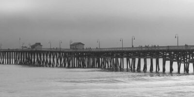
- Santa Monica Pier (CA): The official western terminus—celebrate your achievement!
Accommodation and Logistics
Route 66 offers diverse accommodation options, from historic motels to campgrounds:
Motels
Classic Route 66 motels remain operational throughout the route. Budget $50-100 per night. Many offer cyclist-friendly amenities like early check-in, secure bike storage, and laundry facilities. The Blue Swallow in Tucumcari, El Rancho in Gallup, and Wigwam in Holbrook provide authentic experiences.
Camping
State parks, KOA campgrounds, and dispersed camping opportunities exist along the route. Budget $15-40 per night for established campgrounds. Wild camping is possible in some BLM lands in the western states but requires research and leave-no-trace ethics.
Warmshowers and Hosts
The Warmshowers.org community is active along Route 66. In my experience, hosts in smaller towns are particularly welcoming and often provide invaluable local knowledge.
Resupply Strategy
Plan your resupply towns carefully:
- Major resupply points: Chicago, St. Louis, Tulsa, Oklahoma City, Amarillo, Albuquerque, Flagstaff, Barstow
- Grocery stores: Available in most towns over 5,000 population
- Bike shops: St. Louis, Tulsa, Oklahoma City, Amarillo, Albuquerque, Flagstaff, and the LA area
Safety Tips and Challenges
Drawing from my personal experience and the collective wisdom of countless Route 66 cyclists, here are the critical safety considerations:
Desert Safety
- Carry minimum 4 liters of water capacity; 6+ liters for remote sections
- Start riding at dawn; rest during midday heat (10 AM – 4 PM)
- Know the signs of heat exhaustion and heat stroke
- Electrolyte supplementation is essential, not optional
- Identify bail-out points before entering remote sections
Traffic Concerns
- Interstate parallels exist in many sections—original Route 66 alignments are often quieter
- Shoulder width varies dramatically; some sections have none
- Early morning riding in urban areas reduces traffic stress
- High-visibility gear and lights are essential
Service Gaps
The following sections have significant gaps between services:
- Western Oklahoma: 30-40 mile gaps
- Texas Panhandle: 25-35 mile gaps
- Grants to Gallup, NM: Plan carefully
- Seligman to Kingman, AZ: 70+ miles with limited services
- Mojave Desert (CA): 40+ mile gaps; extreme heat danger
What to Pack: Gear Recommendations
Route 66 requires versatile gear for conditions ranging from sub-freezing mountain mornings to 100°F+ desert afternoons:
Essential Cycling Gear
- Touring bike: Steel or aluminum frame with rack mounts; 32-40mm tires minimum
- Panniers: Waterproof front and rear, or bikepacking bags
- Water capacity: Minimum 4 bottles/bladders; I recommend 6 liters total
- Repair kit: Spare tubes, patch kit, multi-tool, chain links, tire boot
- Lights: Front and rear, USB rechargeable preferred
Clothing
- Moisture-wicking base layers
- Arm and leg warmers for temperature transitions
- Quality cycling shorts (multiple pairs)
- Rain jacket (doubles as wind layer)
- Warm layer for mountain elevations
- Sun-protective long-sleeve jersey
Camping Gear (if applicable)
- Lightweight tent (3-season adequate)
- Sleeping bag rated to 30°F for shoulder seasons
- Sleeping pad
- Compact stove and cookset
Safety and Navigation
- Smartphone with offline maps downloaded
- Physical Route 66 guidebook (EZ66 Guide is excellent)
- First aid kit with blister care
- Sunscreen SPF 50+ and lip balm
- Sunglasses and clear lenses for dawn/dusk
Related Long-Distance Routes
If Route 66 has captured your imagination, consider these other epic American cycling routes:
- TransAmerica Trail – The classic coast-to-coast route, 4,200+ miles from Virginia to Oregon
- Pacific Coast Highway – 1,600 miles of stunning coastal riding from Canada to Mexico
- Great Divide Mountain Bike Route – 2,700 miles along the Continental Divide for off-road enthusiasts
- Southern Tier Route – 3,000+ miles across the southern United States
Final Thoughts
Cycling Route 66 is more than a physical challenge—it’s a journey through American history, culture, and landscape. From my years of experience on this road, I can promise you’ll encounter unexpected kindness, stunning beauty, genuine hardship, and ultimately, profound satisfaction.
The Mother Road rewards those who approach it with respect and preparation. Take your time, talk to the locals, stop at the quirky attractions, and let the rhythm of the road work its magic. When you finally dip your front wheel in the Pacific at Santa Monica, you’ll understand why generations of travelers have been drawn to this legendary highway.
Get your kicks on Route 66—just do it on two wheels.
Stay in the loop
Get the latest wildlife research and conservation news delivered to your inbox.