The first time I crested Crown Point on my road bike, I had to stop pedaling. Not because my legs were burning from the 700-foot climb—though they were—but because the panoramic view of the Columbia River Gorge stretching toward the horizon literally took my breath away. In that moment, standing at Vista House with the wind whipping through the gorge below, I understood why this route has been drawing cyclists from around the world for over a century.
The Historic Columbia River Highway isn’t just another scenic cycling route. It’s America’s first planned scenic roadway, a marvel of early 20th-century engineering that winds through one of the most dramatic landscapes in the Pacific Northwest. As someone who has ridden this route in every season and condition imaginable, I can tell you with absolute certainty: this is bucket-list cycling at its finest. That’s what makes this topic endearing to us enthusiasts.
Route Overview: What You Need to Know Before You Ride
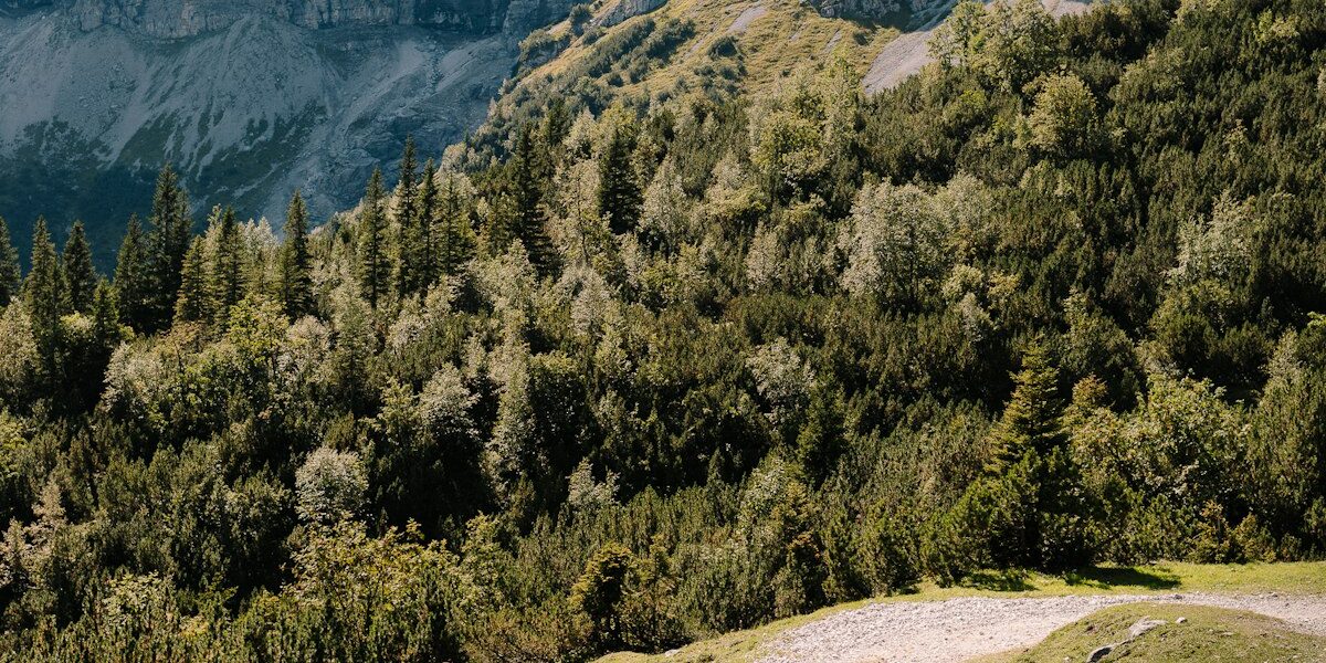
The Historic Columbia River Highway stretches approximately 73 miles from Troutdale to The Dalles, following the south side of the Columbia River through the heart of the Columbia River Gorge National Scenic Area. This isn’t a route you simply pedal through—it’s one you experience, with every mile offering something new: thundering waterfalls, historic stone bridges, hand-carved tunnels, and viewpoints that will have you reaching for your camera repeatedly.
Key Statistics
- Total Distance: 73 miles (Troutdale to The Dalles)
- Elevation Gain: 4,000+ feet cumulative
- Difficulty Level: Moderate to Challenging
- Surface: Paved throughout, with some sections recently restored
- Traffic: Varies by section—some car-free, others shared with vehicles
- Average Completion Time: 6-10 hours depending on fitness level and stops
What makes this route particularly special is its varied character. Some sections are completely car-free multi-use paths perfect for families, while others follow the original 1916 highway with moderate vehicle traffic. The route includes the famous Mosier Twin Tunnels—hand-carved through solid basalt—and passes more than a dozen waterfalls, many of which you can walk right up to.
Best Time to Ride the Columbia River Highway
Having ridden this route in nearly every month, I can confidently recommend May through October as the optimal window for cycling the Historic Columbia River Highway. Here’s what each part of the season offers:
Spring (May-June)
Spring brings the waterfalls to life. Snowmelt from Mount Hood and the surrounding peaks turns every cascade into a roaring spectacle. Multnomah Falls reaches its peak flow in late May, creating that iconic double-drop that graces countless postcards. Temperatures typically range from 55-70 degrees Fahrenheit, perfect for sustained climbing. The trade-off? Occasional rain showers and wet roads, so pack a light rain jacket.
Summer (July-August)
Summer offers the most reliable weather with warm, dry conditions and long daylight hours. Expect temperatures between 75-90 degrees, which can make the climbing segments more challenging. Start early—I recommend being on the road by 7 AM—to beat both the heat and the tourist crowds at popular waterfall stops. Water bottle capacity is critical during these months.
Fall (September-October)
My personal favorite time to ride. The gorge transforms into a corridor of gold, orange, and red as deciduous trees change color. Temperatures moderate to a comfortable 55-70 degrees, crowds thin significantly, and the quality of light for photography is unmatched. Late September through mid-October typically offers the best combination of weather and fall colors.
Detailed Segment Breakdown
Segment 1: Troutdale to Multnomah Falls (22 miles)
Probably should have led with this section, honestly. The journey begins in Troutdale at the Sandy River, where Lewis and Clark first viewed the Columbia River Gorge in 1805. The opening miles roll gently along the river before the route begins its famous climb to Crown Point.
Key highlights in this segment:
- Women’s Forum State Scenic Viewpoint: Your first jaw-dropping gorge vista
- Vista House at Crown Point: The iconic octagonal stone building perched 733 feet above the river
- Latourell Falls: A 249-foot plunge waterfall with a unique columnar basalt backdrop
- Bridal Veil Falls: A two-tiered cascade with a short walking trail
- Wahkeena Falls: Multiple cascades totaling 242 feet
- Multnomah Falls: The crown jewel—620 feet of pure majesty
The climb to Crown Point gains approximately 700 feet over 4 miles at an average grade of 3-5%. It’s sustained but manageable, with several switchbacks that showcase the remarkable engineering of the original highway builders. The descent from Crown Point is technical with tight curves—keep your speed in check and watch for vehicles.
Segment 2: Multnomah Falls to Cascade Locks (18 miles)
Continuing east from Multnomah Falls, you’ll encounter Horsetail Falls right alongside the road—one of the few waterfalls in Oregon where spray can actually reach cyclists on a windy day. The route then enters a more rugged section with several more waterfalls and viewpoints.
Near Ainsworth State Park, the historic highway merges briefly with Interstate 84, requiring cyclists to navigate a 2-mile segment on the freeway shoulder. While this isn’t ideal, it’s well-marked and connects to the next section of historic highway. Oregon DOT has been working on alternatives, so check current conditions before your ride.
The reward for persevering through this section is the arrival at Cascade Locks, a charming river town that makes an excellent lunch stop. The Thunder Island Brewing Company has become a popular cyclist gathering spot, and the historic locks themselves offer fascinating insight into the gorge’s navigation history.
Segment 3: The Mosier Twin Tunnels Section (9 miles)
This is the section that makes cycling photographers weep with joy. The Historic Columbia River Highway State Trail from Hood River to Mosier features the restored Mosier Twin Tunnels—400-foot passages hand-carved through solid basalt cliffs in 1919-1921.
The trail is completely car-free, making it perfect for cyclists of all abilities. The tunnels themselves are illuminated and include viewing windows cut into the rock that frame the gorge like natural artwork. I’ve ridden through these tunnels dozens of times, and the experience never gets old.
Starting from the Mark O. Hatfield West Trailhead in Hood River, you’ll climb gradually for about 4.5 miles to the tunnels, then descend to the charming town of Mosier. The grade averages 3-4%, gentle enough for loaded touring bikes but enough to provide a workout. Interpretive signs along the way explain the history and geology of the region.
Waterfall Highlights Worth Stopping For
The Columbia River Gorge contains the highest concentration of waterfalls in North America, and the historic highway provides access to many of the most spectacular. Here are the must-see cascades:
Multnomah Falls
At 620 feet, Multnomah Falls is the tallest waterfall in Oregon and the second tallest year-round waterfall in the United States. The historic Benson Bridge spans the lower tier, providing a misty photo opportunity that has become synonymous with Oregon tourism. Arrive early to avoid crowds—by mid-morning in summer, parking becomes extremely challenging.
Latourell Falls
Often overlooked by tourists rushing to Multnomah Falls, Latourell is my personal favorite. The 249-foot plunge waterfall drops in front of a stunning columnar basalt amphitheater that glows yellow-green with lichen. A short 0.2-mile trail leads to the base, where spray creates a natural air conditioner on hot summer days.
Horsetail Falls
This 176-foot waterfall cascades directly beside the historic highway, making it the most accessible falls for cyclists. Behind the falls, a trail leads to the equally impressive Ponytail Falls (also called Upper Horsetail Falls), which you can actually walk behind.
Vista House at Crown Point
While not a waterfall, Vista House deserves special mention. This restored 1916 observatory offers 360-degree views of the gorge from 733 feet above the river. The building itself is an architectural gem, featuring a marble interior and a distinctive octagonal design. On clear days, you can see both Mount Hood and Mount Adams from the observation deck.
Accommodation Options for Cyclists
Portland Area (Western End)
Starting from Portland gives you the most accommodation options. The city offers everything from budget hostels to luxury hotels, with easy access to the route via the Springwater Corridor and Marine Drive bike paths. The Jupiter Hotel and Kennedy School McMenamins are particularly cyclist-friendly, with secure bike storage and proximity to bike shops.
Hood River (Eastern Gateway)
Hood River has transformed into the outdoor recreation capital of the gorge. This small city offers numerous lodging options catering to cyclists, including the Hood River Hotel and several vacation rentals. The town’s bike-friendly culture means you’ll find repair services, bike-savvy restaurants, and fellow cyclists at every turn. Discover Bicycles on Oak Street can handle any mechanical issues that arise.
Camping Options
For cyclists seeking a more immersive experience, several campgrounds along the route welcome touring cyclists:
- Ainsworth State Park: Full hookups and hiker/biker sites with hot showers
- Eagle Creek Campground: Rustic sites near stunning trail access
- Viento State Park: Located near Hood River with Columbia River views
- Memaloose State Park: Eastern gorge location with excellent stargazing
Essential Safety Tips
The Columbia River Highway presents unique safety considerations that differ from typical road cycling. Here’s what years of riding this route have taught me:
Traffic Management
Traffic levels vary dramatically by section. The car-free State Trail sections are ideal for all skill levels, but segments of the original highway carry significant tourist traffic, especially between Crown Point and Multnomah Falls on summer weekends. Ride defensively, use mirrors, and consider timing your ride for weekday mornings when traffic is lightest.
Tunnel Safety
The Mosier Twin Tunnels are well-lit, but visibility still decreases significantly inside. Use front and rear lights, even during the day. The tunnel floors can be damp from seepage, so reduce speed before entering. Most importantly, don’t stop in the tunnels to take photos—pull off at the designated viewing windows instead.
Weather Awareness
The Columbia River Gorge is a wind tunnel connecting two dramatically different climate zones. Conditions can change rapidly, and the famous gorge winds can reach 30-40 mph, especially in the afternoon. Check forecasts before departing, and be prepared to adjust your plans if conditions deteriorate. Headwinds traveling west can turn a moderate ride into an epic sufferfest.
Recommended Gear
Based on extensive experience, here’s what I recommend bringing:
- Layers: Temperature can vary 20+ degrees between shaded canyons and exposed viewpoints
- Rain jacket: Compact and waterproof, essential May-June and September-October
- Lights: Front and rear, mandatory for tunnels
- Camera/phone: You’ll regret leaving it behind
- Minimum 2 water bottles: 3 recommended in summer
- Snacks: Services can be sparse between Multnomah Falls and Hood River
- Bike lock: For waterfall hike detours
- Patch kit and spare tube: Cell service is spotty in the gorge
Combining with Other Pacific Northwest Routes
The Historic Columbia River Highway pairs beautifully with other iconic Pacific Northwest cycling routes. Many cyclists combine it with a tour of the Pacific Coast Highway, using Portland as a base for exploring both the coast and the gorge. The Seattle to Portland corridor also connects naturally with the gorge route, creating an extended Pacific Northwest cycling adventure.
For riders seeking more Oregon cycling, the Cascade Lakes Scenic Byway near Bend offers complementary volcanic landscapes and high-alpine riding that showcases a completely different side of Oregon’s cycling diversity.
Final Thoughts
The Historic Columbia River Highway represents everything cycling should be: challenging enough to be rewarding, beautiful enough to be inspiring, and historic enough to connect you with something larger than yourself. Whether you’re a seasoned road cyclist looking for your next adventure or a casual rider seeking a bucket-list experience, this route delivers.
I’ve now ridden this highway more than thirty times, and I still discover something new with each journey—a waterfall I’d missed, a viewpoint I’d passed too quickly, a conversation with a fellow cyclist at Vista House. That’s the magic of the Columbia River Gorge: it reveals itself slowly, rewarding those who return again and again.
So clip in, start pedaling, and let the Historic Columbia River Highway show you why this corner of the Pacific Northwest has been inspiring travelers for generations. I’ll see you at the summit of Crown Point.
Last updated: January 2026. Route conditions verified by the author. Always check Oregon State Parks and ODOT for current trail status and road conditions before your ride.

Stay in the loop
Get the latest cycle routes world updates delivered to your inbox.