
The first time I pedaled onto the Katy Trail near Rocheport, Missouri, I understood immediately why cyclists travel from across the country to experience this remarkable route. The Missouri River stretched out beside me, bluffs towered overhead, and for the next several hours, I had nothing but smooth crushed limestone beneath my tires and 240 miles of America’s longest rail-trail ahead. If you’re planning your own Katy Trail adventure, this comprehensive guide will help you make the most of every mile.
Route Overview: America’s Longest Rail-Trail
The Katy Trail State Park follows the former corridor of the Missouri-Kansas-Texas Railroad (the “MKT” or “Katy” line) for 240 miles across Missouri. Running from Clinton in the west to Machens near St. Charles in the east, this National Recreation Trail holds the distinction of being the longest rail-trail in the United States. The trail parallels the Missouri River for much of its length, passing through wine country, historic towns, and some of Missouri’s most scenic landscapes.
Key Statistics
- Total Length: 240 miles (386 km)
- Surface: Crushed limestone (compacted and well-maintained)
- Difficulty: Easy to moderate (flat to gentle grades, maximum 1% grade)
- Trailheads: 26 official access points with parking
- Elevation Gain: Minimal (approximately 850 feet total over 240 miles)
- Average Width: 10-12 feet
As a former railroad bed, the Katy Trail maintains remarkably gentle grades throughout its length. This makes it accessible to riders of varying fitness levels, though the sheer distance requires proper planning and conditioning for end-to-end attempts.
Best Time to Ride the Katy Trail
Timing your Katy Trail adventure can make the difference between an enjoyable journey and a challenging ordeal. Based on my experiences riding this trail across different seasons, here’s what you need to know.
Prime Season: Spring (April-May) and Fall (September-October)
Spring and fall offer the ideal conditions for Katy Trail cycling. In April and May, wildflowers blanket the trail corridor, temperatures hover in the comfortable 60-75F range, and the Missouri River runs high with snowmelt. Fall brings spectacular foliage along the bluffs, harvest season in wine country, and crisp morning rides warming into pleasant afternoons.
Summer Considerations (June-August)
Missouri summers are notoriously humid, with temperatures regularly exceeding 90F and humidity making it feel even hotter. If you must ride in summer, start at dawn and plan to be off the trail by early afternoon. The tree canopy provides some shade, but heat exhaustion remains a real concern. Carry extra water and plan shorter daily distances.
Winter Riding (November-March)
The trail remains open year-round, though winter brings its own challenges. Frozen ground can make the surface extremely hard, and occasional ice patches require caution. That said, crisp winter days with bare trees offer unique views of the bluffs and river that are obscured during leaf season.
Detailed Segment Breakdown
Breaking the Katy Trail into manageable segments helps with planning overnight stops, understanding the terrain, and anticipating services along the way.
Segment 1: Clinton to Sedalia (35 miles)
This westernmost section runs from the official western terminus in Clinton through rolling countryside to Sedalia. The landscape here differs from the river valley sections, passing through farmland and small communities. Clinton offers full services including bike shops, restaurants, and hotels. The town of Windsor at mile 17 provides a convenient midway stop.
Highlights: Historic downtown Clinton, prairie views, relatively quiet section with fewer cyclists
Services: Clinton (full services), Windsor (limited), Sedalia (full services including Amtrak station)
Segment 2: Sedalia to Boonville (50 miles)
Leaving Sedalia, the trail begins its journey toward the Missouri River. This section passes through more rural landscape before reaching the river valley. The town of Pilot Grove offers services at the midpoint. As you approach Boonville, the terrain becomes more interesting with the river coming into view.
Highlights: Transition to river valley, historic Boonville with excellent dining and lodging
Services: Sedalia (full), Pilot Grove (limited), Boonville (full services, historic downtown)
Segment 3: Boonville to Rocheport (15 miles)
This short but scenic section follows the Missouri River closely. Rocheport is perhaps the most popular destination on the entire trail, a charming village of 200 residents that has fully embraced trail tourism. Multiple B&Bs, restaurants, wineries, and the famous Les Bourgeois winery with its blufftop bistro make this an ideal overnight stop.
Highlights: Missouri River views, Les Bourgeois Winery, historic Rocheport village
Services: Rocheport (B&Bs, restaurants, wineries, bike shop)
Segment 4: Rocheport to Jefferson City (40 miles)
Continuing east from Rocheport, the trail winds through some of its most scenic territory. Towering limestone bluffs rise above the path, and the river remains a constant companion. The small town of Hartsburg offers services at the midpoint. Approaching Jefferson City, you’ll see the state capitol dome in the distance.
Highlights: Dramatic bluffs, river scenery, Missouri state capitol views
Services: Hartsburg (cafe, camping), Jefferson City (full services, state capitol)
Segment 5: Jefferson City to Hermann (55 miles)
This section enters Missouri’s renowned wine country. The towns of Tebbetts, Mokane, and Portland offer limited services, while Hermann at the end is a full-service destination famous for its German heritage and wineries. This is arguably the most popular section for weekend riders combining cycling and wine tasting.
Highlights: Missouri wine country, German heritage of Hermann, numerous wineries
Services: Jefferson City (full), Mokane (limited), Hermann (full services, wineries, B&Bs, Amtrak)
Segment 6: Hermann to St. Charles (45 miles)
The final segment continues through wine country before reaching the eastern terminus near St. Charles. Towns like Augusta and Defiance offer winery visits and services. The trail ends at Machens, though many riders continue on connecting routes to reach downtown St. Charles, a historic community with excellent restaurants and lodging.
Highlights: Augusta wine district, connection to St. Charles historic district
Services: Augusta (wineries, B&B), Defiance (bike shop, dining), St. Charles (full services)
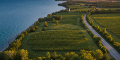
Missouri River Scenery and Wine Country
What sets the Katy Trail apart from other rail-trails is its intimate relationship with the Missouri River and passage through one of America’s oldest wine regions.
River Valley Landscape
For approximately 150 miles between Boonville and St. Charles, the trail hugs the Missouri River, often running directly along the riverbank. Limestone bluffs rise 200-300 feet on the opposite side, creating a dramatic backdrop. Wildlife abounds – I’ve spotted bald eagles, great blue herons, white-tailed deer, and wild turkeys during my rides. The river itself changes character with the seasons, running high and muddy in spring, lower and clearer in fall.
Missouri Wine Country
The section between Hermann and Augusta comprises the heart of Missouri wine country. German immigrants established vineyards here in the 1830s, and the region produced more wine than any other American wine region before Prohibition. Today, dozens of wineries welcome cyclists, many with patios and bistros perfect for a mid-ride break. Norton, the official state grape, produces robust red wines unique to Missouri.
Accommodation Options Along the Trail
The Katy Trail’s popularity has spawned excellent lodging options catering specifically to cyclists.
Bed and Breakfasts
Rocheport and Hermann offer the greatest concentration of B&Bs, many in historic buildings with designated bike storage. Expect to pay $100-200 per night, with full breakfasts included. Booking well in advance is essential during fall foliage and wine harvest seasons.
Camping
Several designated camping areas serve trail users, including facilities at Rocheport, Hartsburg, and Jefferson City. Primitive camping is also available at various points. The Missouri Department of Natural Resources maintains updated information on camping facilities. Expect basic amenities – water, restrooms, and level tent sites.
Trail Towns
The larger trail towns (Clinton, Sedalia, Boonville, Jefferson City, Hermann, St. Charles) offer standard hotel and motel options. Many have designated bicycle-friendly accommodations with secure storage and early breakfast options for riders wanting an early start.
Safety Tips for Katy Trail Riders
While the Katy Trail is generally safe and well-maintained, attention to a few key areas will enhance your experience.
Surface Conditions
The crushed limestone surface is well-compacted but can become soft after rain. Puddles may form in low spots, and the surface can be loose where maintenance crews have recently added material. After heavy rain, give the trail a day or two to firm up before riding. Watch for occasional root heaves and washouts, particularly after spring floods.
Water Crossings
The trail crosses numerous creeks and small streams on bridges. A few sections use low-water crossings that may be impassable after rain. Check trail conditions online before departure, especially if planning segments between Jefferson City and Hermann where flooding occasionally closes short sections.
Other Trail Users
The Katy Trail sees significant horse traffic in some sections. Horses have right-of-way; stop, speak calmly to the horse and rider, and wait for them to pass. Walkers and runners share the trail as well. Use your bell or voice to announce when passing.
Services and Resupply
Some trail segments run 25-30 miles between services. Carry sufficient water (I recommend minimum 80 ounces for longer segments), snacks, and basic repair supplies. Cell service can be spotty in the river valley, so don’t rely on your phone for emergency assistance in remote areas.
Gear Recommendations for Crushed Stone Surface
The Katy Trail’s crushed limestone surface influences equipment choices significantly.
Tire Selection
Wider tires are essential for comfort and control on crushed stone. I recommend minimum 35mm width, with 38-42mm being ideal. Gravel-specific tires with some tread pattern handle the occasional loose sections better than slick road tires. Run lower pressure than you would on pavement – around 40-50 PSI depending on your weight and tire width.
Bike Choice
While any bike can technically ride the Katy Trail, certain styles excel. Gravel bikes offer the best combination of efficiency and comfort. Hybrid bikes work well for casual riders. Touring bikes loaded with panniers handle the smooth surface easily. Mountain bikes work but are overkill – the suspension adds weight without benefit on this flat, smooth trail. Road bikes with tire clearance for 32mm+ can work but sacrifice comfort.
Essential Gear
- Spare tubes and patch kit (crushed stone hides occasional thorns)
- Frame pump or CO2 inflators
- Multi-tool with chain breaker
- Water bottles or hydration pack (minimum 80 oz capacity)
- Sunscreen and lip balm
- Lightweight rain jacket (Missouri weather changes quickly)
- Bike lights (several tunnels on the trail, plus early/late riding)
Connecting to Other Great Rail-Trails
The Katy Trail can be combined with other major trail systems for extended adventures.
For riders seeking similar experiences, the C&O Canal Towpath offers 184 miles of car-free riding along the Potomac River with similar crushed stone surface and historic character. Combined with the Great Allegheny Passage, East Coast riders can enjoy over 330 miles of continuous trail between Pittsburgh and Washington, D.C.
These three trails represent the finest rail-trail cycling experiences in America, each offering unique landscapes and histories while sharing the accessibility and gentle grades that make rail-trails so appealing to cyclists of all abilities.
Final Thoughts
The Katy Trail offers something increasingly rare in American cycling: the opportunity to ride for days through varied landscapes without ever encountering motor vehicle traffic. Whether you’re seeking a weekend wine country escape or a week-long end-to-end adventure, this remarkable trail delivers experiences that stay with you long after the ride ends. The combination of Missouri River scenery, historic trail towns, welcoming wine country, and smooth riding surface creates a cycling destination that rivals any in the nation.
Start planning your Katy Trail adventure today. The trail awaits, stretching 240 miles across Missouri’s heartland, ready to provide the journey of a cycling lifetime.


Stay in the loop
Get the latest cycle routes world updates delivered to your inbox.