What the Via Rhôna Actually Is
Cycling routes have gotten complicated with all the marketing noise flying around. As someone who spent three weeks riding EuroVelo 17 last May, I learned everything there is to know about the Via Rhôna. Today, I will share it all with you.
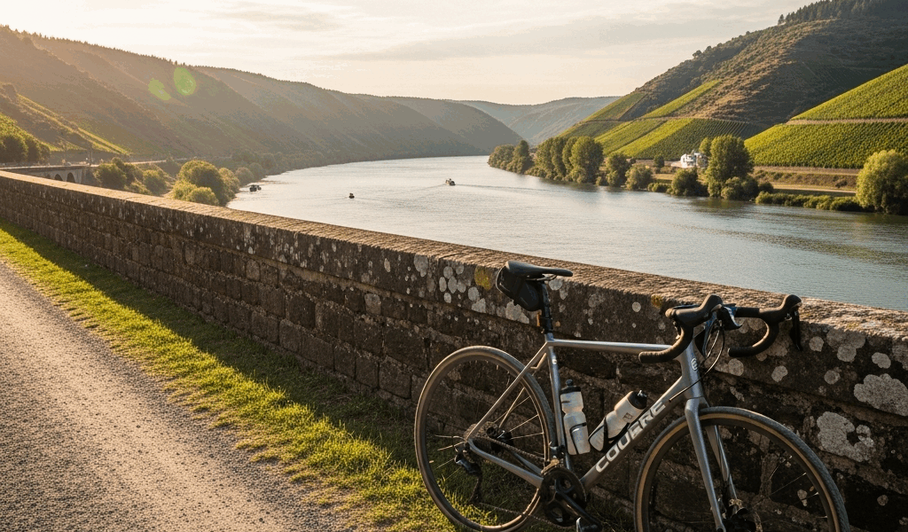
But what is the Via Rhôna? In essence, it’s a legitimate 815-kilometer signed cycle route stretching from Lake Geneva to Port-Saint-Louis-du-Rhône on the Mediterranean. But it’s much more than that. It’s not a brochure fantasy — it’s a real road trip on two wheels through one of France’s defining river corridors, and honesty about what you’re actually getting into matters more than hype.
The defining feature is simple: the route hugs the Rhône River almost the entire way. You’re not grinding up Alpine passes or threading cobblestoned village backstreets. You’re following one of Europe’s great waterways as it barrels south from the Alps toward the sea. That’s what makes the Via Rhôna endearing to us cycling tourists.
Here’s the honest breakdown. Roughly 60% of the route is purpose-built, dedicated cycle path. The remaining 40% mixes secondary roads, tertiary road sections, and occasional gravel transitions — some of which turn genuinely muddy after rain. Not 815 kilometers of perfect tarmac. Several stretches between Lyon and Valence run on narrow local roads where cars appear regularly. A few sections south of Avignon are graveled paths that become properly difficult in wet conditions. This matters for tire choice. It matters for your head, too.
Most recreational cyclists complete the Via Rhôna in 10 to 14 days, averaging 60 to 80 kilometers per day. The route is almost entirely flat — elevation gain rarely exceeds 300 meters in any single stage. If you’ve ridden a multi-day touring route before, you already know what to expect physically. If you haven’t: the Via Rhôna is beginner-friendly in gradient but demands consistent saddle time. Day after day. No shortcuts there.
Stage Breakdown and Difficulty Overview
Stage 1: Geneva to Bellegarde-sur-Valserine (43 km)
This opener runs almost entirely on dedicated path — smooth tarmac hugging the lake’s southern shore, then following the young Rhône as it tumbles out of Geneva. Navigation is trivial. The route is signed at every junction. You’ll share the path with weekend riders and families pulling trailers. Finish in Bellegarde if you want a short, comfortable first day, or push another 20 kilometers to Culoz. Bellegarde itself is industrial and not worth lingering in — cheap beds, though, and the next stage rewards the early positioning.
Stage 2: Bellegarde to Lyon (130 km)
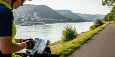
The longest single stage on the route. Split it across two days if your fitness is uncertain — Ambérieu-en-Bugey sits right at the 65-kilometer mark and works well as a rest stop. The terrain character shifts here. You leave the Alpine foothills and drop into the flatter Rhône valley proper. About half the stage runs on dedicated paths; the rest alternates between quiet secondary roads and suburban town cycling. Surface consistency drops noticeably. Gravel sections appear near Meximieux — nothing brutal, but enough that tire pressure and frame clearance start to matter. Lyon itself is a genuine navigation challenge. The EuroVelo 17 signs are mostly clear, but you will miss them on narrow residential streets. Download offline maps before you leave Geneva. Seriously.
Stage 3: Lyon to Valence (110 km)
Probably should have opened with this section, honestly. This is where the Via Rhôna shows its seams. Dedicated path infrastructure drops dramatically. You’re on regional roads for roughly 70 kilometers — traffic isn’t heavy, but it’s present and consistent. The landscape flattens further into broad agricultural stretches: corn, sunflowers, market gardens. Accommodation thins out between towns. Saint-Vallier and Tournon-sur-Rhône are reasonable stopping points. The river itself disappears from view for long stretches because the route gets pushed back onto roads running parallel to the valley floor rather than actual riverside paths. Surface quality is reasonable tarmac throughout — just don’t expect the silky dedicated-path experience of the first two stages. It’s not that.
Stage 4: Valence to Avignon (145 km)
Split this into two days. Most cyclists stop in Montélimar — about 75 kilometers from Valence — which is the sensible call. The Mistral wind becomes genuinely relevant starting here. I’ll cover that properly in the weather section, but anticipate headwind even on days when the forecast looks calm. Provence opens up properly on this stage: limestone cliffs, more picturesque villages, dedicated paths returning in sections around Donzère and between Bollène and Avignon. Gravel transitions appear regularly from Montélimar onward. A gravel-capable tire stops being optional and starts being necessary. Accommodation demand spikes sharply here — this is where the cycle route meets mainstream leisure tourism. Book ahead in summer. I cannot stress this enough.
Stage 5: Avignon to Arles (38 km)
Short stage. Worth savoring slowly. Path quality is mixed — excellent dedicated sections interrupted by narrow gravel stretches. You’re cycling into the Camargue now, the marshy delta region where flamingos stand in roadside pools and wild bulls graze behind wire fencing. It’s striking. Avignon itself is crowded and confusing to navigate — leave early before the tourist foot traffic builds. Arles is the logical finish point for most riders, even though the official route pushes another 45 kilometers to Port-Saint-Louis-du-Rhône. Arles has direct TGV connections back to Paris. It’s a sensible and genuinely satisfying place to stop.
Stage 6: Arles to Port-Saint-Louis-du-Rhône (45 km)
Only ride this if you committed from the start to finishing at the Mediterranean. The path quality here is the worst on the entire route — gravel and occasional mud dominate, the landscape turns industrial and functional, and there’s no accommodation at the finish. It’s a working port. The psychological reward of touching the sea is real. The final kilometers are grinding rather than euphoric, though. Don’t make my mistake of expecting a triumphant finale. It’s not that kind of ending.
Where to Sleep Along the Via Rhôna
Accommodation strategy shifts depending on season and budget. Campgrounds run the full length of the route — expect to pay €15 to €25 per night. Camping des Trois Lacs near Bellegarde is reliable for the first night. Camping Parc de la Drôme near Montélimar has laundry facilities and strong wifi, which becomes essential after 70 kilometers on gravel roads.
Gîtes d’étape — essentially cycling-aware pilgrim hostels — dot the route and typically cost €20 to €35 for a bed, often with kitchen access and owners who actually know what cyclists need. That’s what makes them endearing to us long-distance riders. The gîte network thins noticeably between Lyon and Valence — not a tourism-heavy corridor — so expect fewer options and faster fill-ups. Book these at least 5 to 7 days ahead during July and August. Earlier if you can manage it.
Budget hotels run €50 to €80 per night and appear in every town large enough to have a train station. Lyon, Montélimar, Avignon, and Arles all have multiple chain options — Ibis, Formule 1, Premier Classe — where a room is guaranteed even without advance booking. Smaller towns like Culoz and Bollène have family-run two-star hotels that are cheaper and considerably warmer in atmosphere.
I’m apparently someone who underestimates August tourism demand, and spontaneous booking works for me in May while it never works in peak summer. Don’t make my mistake. I arrived in Montélimar on a Friday evening in mid-August and cycled through twelve accommodation calls before finding a camping spot 8 kilometers outside town. May and September you can often show up and find beds without drama.
Best Time to Ride and What to Watch For
May and June are ideal — temperatures between 18 and 25 degrees Celsius, infrequent rain, tourist infrastructure present but not saturated. The Mistral wind hasn’t peaked yet. So, without further ado, let’s dive into the seasonal reality.
September runs a close second to May. Heat is less oppressive than July, the Mistral still blows but less viciously, and accommodation is genuinely easier to find. Riverside paths occasionally close during spring snowmelt — rare, but it happens. Check local reports in April before you depart if you’re planning an early-season ride.
Avoid July and August unless you’re committed to crowds, heat exceeding 30 degrees in the southern valley, and Mistral gusts hitting 60 kilometers per hour. That’s not a pleasant combination on a loaded touring bike.
The Mistral deserves its own honest paragraph. It’s not folklore — it’s a consistent katabatic wind funneling from the northwest through the Rhône valley corridor, and it makes southbound cycling genuinely difficult. Frustrated by the experience of spending 4.5 hours covering just 52 kilometers on a supposedly flat stage, I started treating headwind days as scheduled events rather than anomalies. Because they are. Ride early. Start at 6:30 AM, aim to finish by 1:00 PM before afternoon gusts peak. That single adjustment changed everything about the southern stages.
What to Pack and How to Get There
Panniers work better than bikepacking bags on this route. The wind in the south is strong enough that weight distribution and a low center of gravity matter for stability in crosswind. I used 40-liter Ortlieb Back-Roller Classic panniers and rarely exceeded 18 kilograms total load. Panniers aren’t lighter — they’re steadier. If you’re already committed to a bikepacking setup, it functions fine, just expect slightly slower average speeds on gusty days south of Lyon.
While you won’t need a full workshop in your panniers, you will need a handful of repair essentials. A spare tube minimum — actually, two. A chain tool, brake pads, and a spoke wrench. The gravel sections produce punctures. Brake pads wear faster when you’re braking in sandy conditions with the wind pushing you. A basic multitool and a pump are non-negotiable. First, you should check your cassette before leaving — at least if you haven’t replaced it in the past 3,000 kilometers.
Tire clearance might be the best single decision you make for this route, as the Via Rhôna requires handling both smooth tarmac and rougher gravel without losing hours in either direction. That is because the surface character changes every 20 to 30 kilometers on the middle and southern stages. A 700c x 45mm all-rounder works perfectly — Panaracer Gravel King or Schwalbe G-One are both solid choices. Avoid narrow road slicks. Avoid aggressive knobby mountain tires.
Getting there: book a TGV from Paris Gare de Lyon to Geneva. The journey takes 4.5 hours and costs €60 to €120 depending on how far ahead you book. Your bike travels in a bike bag — roughly €15 — or a free cardboard box from most bike shops. I used a Deuter Travel Bike Bag, stored it at a hotel near Geneva station the night before starting. Straightforward. Getting home: finish in Arles and take the TGV back to Paris, about 4 hours and €50 to €120. The Arles station staff will box bikes for travel. Port-Saint-Louis-du-Rhône has no realistic transport options unless your tour continues onward toward Barcelona.
Stay in the loop
Get the latest cycle routes world updates delivered to your inbox.